In the distant Shetlands Islands 130 miles North of Scotland there’s a second-hand bookshop in, as we might say, the middle of nowhere – the Hatchery Bookshop. It stands on the B9075 road North of the tiny hamlet of Weisdale.
What you may ask does this have to do with Montana?
The answer is that this map was purchased earlier this month in the bookshop, price £1 (about $1.25):

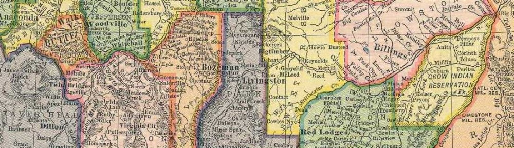
A Texaco highway map of Montana – ‘Trust your car to the man who wears the star’. On one side a detailed map of Montana at a scale of 1 inch to 26 miles, with a larger scale inset of Glacier National Park. On the other, plans of downtown Butte, Great Falls, Helena and Billings, two more inset maps – Yellowstone National Park and the Black Hills Region of South Dakota – a Transcontinental Road Map, a mileage chart, a list of visitor attractions, and an assurance that you can use your Texico credit card to ‘charge lodging and related services when you stay at all Howard Johnson’s Motor Lodges’.
The date – tucked away in one corner of the legend – 1967.
So, the question. How does a 56 year old map of Montana end up in a bookshop in Shetland?
We’ll never know the answer, just as I’ll never know why my good Montanan friend Don was able to find, and gift me, a British union jack from an antique shop in his own state.
Anyhow, here’s my guess as to my Texaco map’s journey.
A route has been marked in pen on the map from Spokane in Idaho, through Missoula, Butte and onwards South to Yellowstone.

I suspect these were British tourists on vacation travelling to or from the West Coast and marking their route on a detailed highway map of the state. They brought their maps home with them on their return (great souvenirs) and eventually ended up living in Shetland.
Well, it’s an unprovable theory as good as any.
I did a similar thing on my one visit to Montana in 1968, a year after the Texaco map was published. It’s recorded on the first entry in this blog – Once upon a time. You’ll see there that my journey, by Greyhound, also ended in Yellowstone, though it ran North-South, unlike the owners of this map, whose route ran more West-East. We must have crossed somewhere near Butte, probably within a few months of each other.
The marks on the Texaco map suggests that its owner did much the same as me – Montana was a place to get through as quickly as possible to somewhere we thought more interesting. How wrong we were.
Footnote. In 1968 the student travel service I went with to the USA recommended getting free maps of each state at a convenient gas station and I still have a small collection. I assume this Texaco map was a similar free offering. With the advent of Google maps and GPS I can’t imagine the same service continues and that they were very much of their era. But a great service and great maps (even if my older eyes now struggle to read some of the detail).

